

Lap of Tasmania Clockwise
All Regions: Highways 1, A3, A10, A2
970 km 14.0 hours
Page Section Links
Devonport to Launceston
Devonport to Launceston
North West & North East Regions: Highway 1
100 km 1.0 hours
Fuel and Food Stops
(Latrobe 11 km)
Sassafras 20 km
Elizabeth Town 41 km
(Deloraine 52 km)
(Westbury 67 km)
Launceston 100 km
General Info
The main road east from Devonport to Launceston is Highway 1.
Known as the Bass Highway, the road is in good condition with plenty of overtaking lanes and a good choice of places to stop along the way.
The Bass Highway is the shortest and fastest way from Devonport to Launceston. If you have a little more time there are a couple of more interesting, alternative ways to make the same journey.
Police presence is moderate with unmarked cars and bikes enforcing speed limits, including at road works.
Watch Out For …
Trucks
Mobile speed cameras
Police patrols including unmarked cars and bikes.

Directions
If you are just getting off the boat, it will probably be 7.00am, or even earlier, when you disembark.
There are a number of cafes open early for breakfast and coffee, both in East Devonport and over the bridge in the Devonport CBD.
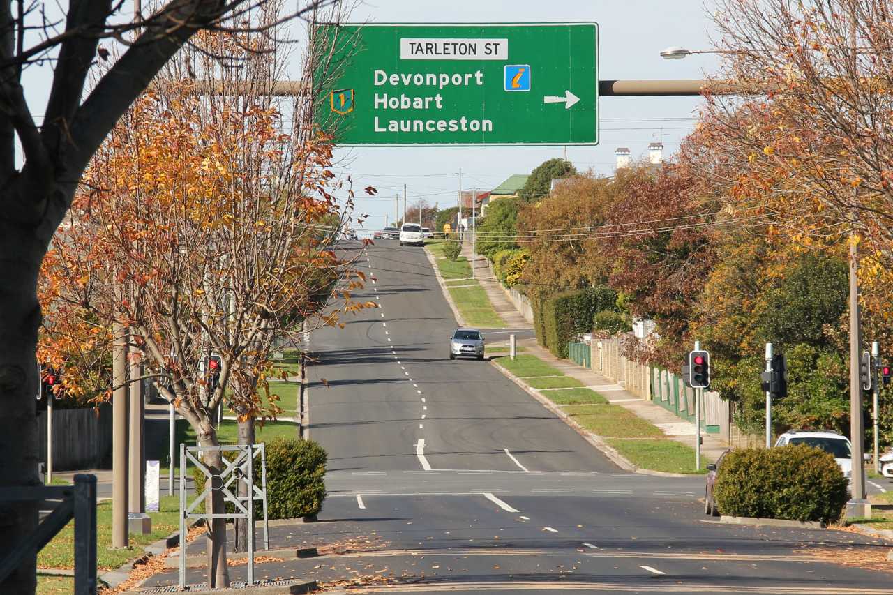
After clearing the quarantine station, exit the ferry terminal and turn left onto Murray Street.
Proceed through the roundabout and then turn right at the next intersection (Tarleton St.)
There are cafes and fuel stops on Tarleton Street if required.
At the end of Tarleton St the road branches into two, with the left lane taking you east towards Launceston and the right lane heading you west over the bridge towards Devonport CBD.
SPEED CAMERA ALERT !
There are fixed speed cameras on the approach to the bridge as you head into Devonport city centre. The speed limit at time of writing was 80 km/h.
The Bass Highway (Highway 1) is a major transport link with quite a few trucks, but plenty of opportunities for overtaking.
If you prefer to get on the road straight away, there are great cafe options at Latrobe, Elizabeth Town and Deloraine.
Anvers Chocolates, Ashgrove Cheese, Elizabeth Town Bakery and Christmas Hills Raspberry Farm are all on the main highway, and before the halfway point at Deloraine
Deloraine is worth a look, with the picturesque Meander River and a thriving arts community.
From Deloraine you can continue on the highway to Launceston, or take one of the alternate routes with lower speed limits and less traffic.
There is not much to stop for between Deloraine and Launceston and the road conditions and scenery are similar to the previous 50km.
The approach to Launceston takes you past Richardson’s Harley Davidson and The House of Motorcycles at Prospect.
Keep to the left hand lane and swing left onto the Southern Outlet which takes you down the hill and into Launceston city centre.
Click Here To Explore Alternative Routes

Hidden Gem
Island State Brewing – The Pier, Ulverstone


Useful Links
Tasmanian Weather Forecasts
Accommodation
Meals
Tasmanian Events
Breweries, Wineries and Distillers
Motorcycle Mechanics and Dealers
Secure Parking
Launceston to St. Helens

Launceston to St. Helens
North East Region: Highway A3
161 km 2.5 hours
Fuel and Food Stops
Nunamara 21 km –
Closed due to fire damage
Myrtle Park 32 km
Sideling Lookout 43 km
Scottsdale 62 km
Branxholm 88 km
Derby 95 km
Weldborough 117 km
(Pyengana 137 km)
St. Helens 158 km
General Info
The Tasman Highway A3 winds it’s way through a variety of landscapes from rain forest to open pastures.
From Launceston to St. Helens the road is two lanes only and varies from fast, open sweepers to tight hairpins.
The condition of the road is also variable, but mostly pretty good, with some of the bumpier sections undergoing recent upgrades.
Police presence is moderate with unmarked cars and bikes and occasional mobile cameras enforcing speed limits.
Watch Out For …
Trucks and caravans
Gravel on corners
Road kill
Mobile speed cameras
Police patrols including unmarked cars and bikes.

Directions
Head south east out of Launceston along Elphin Road.
Turn left at the traffic lights at Hoblers Bridge Road.
Take the left hand exit at the next roundabout and you are then on the Tasman Highway that will take you all the way through to St. Helens.
The road is fairly fast and open for the next 20 km or so but there are long stretches of double white lines until Nunamara, so overtaking opportunities are a bit limited.
There is the occasional sharper corner, including the 35 km/h hairpin at Myrtle Park but most are well sign posted.
CAUTION !
400 metres after the Myrtle Park hairpin there is a crest in the road. At this point the power poles continue straight but the road kinks to the left. Riders have been caught out here, expecting the road to follow the power lines straight ahead.
The Sidling
From the start of The Sidling there are about 16 km of twists and turns, up one side of the hill and down the other.
This is a favourite track for Launceston based riders and most have a story about their experience on the notorious Sidling.
Either they’ve crashed, or their friend crashed or they got a big fright on this challenging stretch of road.
The first few kilometers of The Sidling are a bit bumpy and the road is narrow. Overtaking can be tricky, but hey, you’re on a bike.
There are rock walls on your right hand side and very steep drop-offs on the left. It’s not the sort of place you want to accidentally leave the road.
Beware of debris on corners, such as gravel, bark and leaves. Longer vehicles often cross the centre line on the tighter corners.
CAUTION !
Don’t get carried away when you see a section of straight road ahead – every short stretch of straight road on The Sidling has a pretty sharp corner at the end of it.
Just after the highest point, as you start the downhill run, there is a lookout on the right hand side, with public toilets and a viewing platform. There is also a roofed shelter which could be handy if you get caught in the rain.
After the lookout it’s all downhill and recently rebuilt following landslides that closed the road for several months. The corners are smooth and wide and great fun, especially going the other way, up the hill.
After you come down off The Sidling the road is very smooth with some lovely flowing corners that will take you all the way into Scottsdale.
Scottsdale
Scottsdale is the largest town in the north east area, serving as a hub for the surrounding farming communities. Here you will find accommodation and food, a variety of services and a Suzuki dealership.
After Scottsdale the road is fairly open again with a few tighter corners in the run up the hill before Branxholm.
Derby
Just 8km past Branxholm is the old tin mining town of Derby.
Derby used to be a sleepy, rather run-down place where, 10 years ago you could buy a house for $30,000.
The construction of world class mountain bike tracks have recently transformed Derby into a thriving hub with new bars, restaurants and accommodation.
Derby is busy on weekends and holidays and there are numerous buses with bike racks on the back, ferrying riders to the start of the trails.
The road and scenery changes dramatically about 12km past Derby when you enter the Weldborough Pass

Weldborough Pass
This section is very similar to The Sidling, but with a prehistoric rainforest vibe.
Very tight corners, with plenty of 25km/h and 35km/h sign posted bends. There is little direct sunlight in some areas so there is a sheen of green moss on parts of the road.
Be careful if it is damp or raining, it can be slippery, particularly in the section signposted as “Myrtle Forest”.
The Weldborough Pub has had a few different owners over the years, but the current crew seem to be getting very good reviews. Open 7 days a week, with meals and on-site camping.
The 8km of road after the pub has some fun flowing corners and is a highlight of this section.
After the rainforest, the road opens out again into farm country and your next potential stop is Pyengana.
Pyengana
The Pub In The Paddock serves counter meals and has accommodation rooms available. And you can shout Priscilla the pig a beer as well.
I have stayed overnight here a few times and always had a good meal and an enjoyable night.
The pub is only 2.5km from the turn off (C428).
You will pass the Pyengana Dairy, Farmgate Cafe on your way to the pub. The dairy is famous for it’s cheese and the cafe is a great spot for breakfast.
In cooler months the wood heater in the cafe is great for a warm up.
Open from 9.00am to 5.00pm with food until 3.00pm. The shop has stocks of gourmet Tasmanian produce and gifts.
From the Pyengana turn off it’s only 26 km to St.Helens. The first 10 km or so is more twisty but not too tight, then the road straightens out a bit for the run into the town.
About 6 km before St.Helens you will pass the Shop In The Bush, which has antiques, books and a wide variety of unusual gifts.
Just the spot if you’re into crystal chandeliers, Elvis albums and old books. And they have an open fire in cooler months.
St. Helens
S’neluns is the largest town on the east coast of Tasmania and a popular tourist and local holiday destination. Lots of accommodation options here and it’s a good base for exploring the entire north east region.
Click Here To Explore Alternative Routes

Hidden Gem
The Cottage Bakery – Scottsdale


Useful Links
Tasmanian Weather Forecasts
Accommodation
Motorcycle Related Events
Breweries, Wineries and Distillers
Mechanical
Secure Parking
St Helens to Hobart

St Helens to Hobart
North East, East & South Regions: Highway A3
254 km 3.5 hours
Fuel and Food Stops
Scamander 18 km
Bicheno 76 km
(Coles Bay 114 km)
Swansea 119 km
(Triabunna 169 km)
Orford 175 km
Buckland 231 km
(Richmond 231 km)
Sorell 228 km
Cambridge 242 km
Hobart 253 km
General Info
The East Coast is a major destination for Tassie residents so it’s always busy at holiday times.
Expect to encounter locals towing boats and caravans and plenty of tourists in hire cars during summer, Easter and public holidays.
The whole east coast highway is in good condition but it does seem pretty narrow compared to other main roads. It’s barely wider than a standard car, so allow for that in your riding.
Police presence is moderate with unmarked cars and bikes enforcing speed limits.
Watch Out For …
Tourists and caravans
Road kill
Narrow road
Mobile speed cameras
Police patrols including unmarked cars and bikes.

Directions
Head south on the A3 out of St. Helens, past the wharf area and over the bridge.
After a few kilometres the road swings out to the coast and sticks close to the beach until you reach Scamander.
About 6 kms past Scamander you will come to a major intersection and have a decision to make.
St. Marys Pass & Elephant Pass
Going straight ahead will put you on the St. Marys Pass, with some very tight corners, double white lines and reduced speed limit.
It’s only 5 kms to St. Marys, and then to get back on the A3 you head south east through the Elephant Pass. It’s 11 km of non-stop corners with 80 km/h and 60 km/h speed limits.
Turning left at the intersection keeps you on the A3, sticking close to the coast and with a shorter distance and 100 km/h speed limit.
St. Marys has everything you might need as far as fuel, food, accommodation etc but it’s not really seen as a major destination.
If you love corners, then going over the passes is good fun. If you are time constrained, stick with the main road.
The highway continues to hug the coast offering glimpses of amazing scenery and magnificent east coast beaches.
Just before Bicheno, on the left hand side, is the Nature World wildlife park, where they 100% guarantee you will see a Tasmanian Devil.
Bicheno
Bicheno is a holiday destination for Tassie locals, similar to St.Helens in many ways, busy at holiday times and pretty quiet during the winter.
There are a range of accommodation options in Bicheno including some funky new two-storey units on the site of the old Silver Sands Motel.
Nightly penguin tours are available to watch the critters come out of the sea and up to their burrows.
Unfortunately the motorcycle museum has closed down, even though there are still some references to it online.
11kms south of Bicheno is the turn off to Coles Bay and the Freycinet Peninsula. Click here for info on this spectacular side trip.
Just past the Coles Bay turn off is The Pondering Frog, a cafe that’s open 365 days a year with breakfast, lunch and handcrafted, local ice-cream (for breakfast, if you like).
Continuing south, you are now heading into wine country, with six well regarded vineyards on the map before you reach Swansea.
First up is Freycinet Vineyard with cellar door sales and a reputation for premium wines.
Devils Corner is next, offering unique cellar door architecture, gourmet pizzas, local seafood and open 7 days a week. (see pics below)
Gala Estate, Craigie Knowe, Springvale and Milton wineries are next in line with Craigie Knowe and Milton offering lunches at their cellar doors.
Swansea
Next town south is Swansea, and on the way you will pass the turn off to the Lake Leake Highway, which takes you up over the mountain and down into Campbell Town, on the Midlands Highway.
Swansea is right on the coast and probably has more permanent residents (retirees) than holiday homes.
There are a couple of cool restaurants in Swansea and great pizzas at the Bark Mill Tavern and Bakery. Swansea has accommodation options and good facilities including the May Shaw medical centre.
About 16 km south of Swansea is the Mayfield Estate, a farm and vineyard and the site of the annual Spoke Motorcycle Festival.
If you’re going past at the right time, you must call in for a look. Click here for details or see our events page.

Triabunna
From Swansea to Triabunna there is a mix of light bush and farmland, and that slightly narrow, east coast road feel continues.
Triabunna is the port for the Maria Island ferry. The ferry doesn’t take vehicles but you can hire bicycles on the island, which is a national park.
Triabunna has a 24 hour fuel depot, but what the hell are you doing out in the dark anyway?
Orford
Just 6 kms further on is the town of Orford. You will pass a pub and a couple of cafes on your way into town and if you keep going to the bridge there are more cafes and and IGA supermarket.
Check out our Hidden Gem for Orford ( see below). It’s definitely worth the 10 minute diversion.
Leaving Orford, heading south, your track winds beside the Prosser River on your right and steep rock walls on the left. Major rockfalls closed the road for months back in 2021 but there have been no reported problems since thaat time.
Buckland
Buckland is a small place, just 14km down the road and has fuel, a roadhouse, a pub and limited accommodation.
After Buckland the countryside is quite hilly for the next 11 km, with fun corners up and down steep sections which are susceptible to ice and frost during winter.
The road opens out again for the run down to Richmond and Sorell.
Sorell
If you are heading down to Port Arthur, stay on the main road (A3) and continue into Sorell. The A3 will also take you into Hobart via the Midway Point causeways and past the airport.
Richmond
If you are heading for Hobart it’s better to turn off to the right, before Sorell and go through the historic village of Richmond. Both the C350 and C351 roads will get you there.
Richmond has the oldest stone span bridge in Australia, dating from 1823 and the town is full of old sandstone buildings, a good pub and plenty of cafes, shops and galleries.
Heading south from Richmond on the B31, towards Cambridge, will take you past a number of top Tasmanian vineyards, restaurants and cheese producers. At Cambridge you will rejoin the A3 for the run into Hobart.
Just after leaving Richmond you could swing right onto the C234 and head over Grasstree Hill Road, go through Risdon Vale and over the Bowen Bridge into Hobart.
This route looks pretty good on the map, with lots of corners, but speed limit reductions and encounters with cyclists have reduced the popularity of this once favourite track.
Stick to the B31 and enjoy the many options for wine and cheese stops.
SPEED CAMERA ALERT !
After you pass the airport on the A3 there are fixed speed cameras opposite the Cambridge shopping centre. You will bypass these if you’re coming from Richmond and definitely go through them if coming from Sorell.
The speed limit at time of writing was 110 km/h.
This whole area between Sorell, Richmond and Hobart is a hot spot for mobile speed camera trailers.
SPEED CAMERA ALERT !
There are fixed speed cameras on the Tasman Bridge and the speed limit is 70 km/h, or as signed.
Traffic in the city centre can get quite congested at peak commuting times. There are many one-way streets in Hobart so you might find yourself doing a few laps to get exactly where you want to go.
There are a few free motorcycle parking spots in Davey Street and at Salamanca Place. You will be fined if you park on the footpath.
Click Here To Explore Alternative Routes

Hidden Gem
Bluff Road Lookout – Orford


Useful Links
Tasmanian Weather Forecasts
Accommodation
Tasmanian Events
Breweries, Wineries and Distillers
Mechanical
Find a Dealer By Brand
St. Helens – East Coast Motorcycles 0408 763 163
Secure Parking
Hobart to Queenstown

Hobart to Queenstown
South, Central & West Regions: Highway A10
261 km 3.75 hours
Fuel and Food Stops
New Norfolk 36 km
Gretna 56 km
Hamilton 74 km
Ouse 89km
(Tarraleah 127)
Derwent Bridge 175 km
Queenstown 261 km
General Info
Tasmania’s west coast is the most remote area of the state, with a small and scattered population.
The terrain is mountainous and heavily forested with a high annual rainfall. If you are in the west for a couple of days or more you will most likely get some rain, no matter the time of year.
The Lyell Highway (A10) takes you close to the geographical centre of Tasmania and runs through a variety of country from open farmland to tight rainforest curves and steep mountain passes. The road is in good condition and traffic is light.
Police presence is light with unmarked cars and bikes enforcing speed limits, including at road works.
Watch Out For …
Tourists and Caravans
Log Trucks
Wildlife and Road Kill
Tight Corners and Wet Roads

Directions
Depart from Hobart city on the Brooker Highway (A1) and head north towards Launceston. Around 18km from the city you will come to a roundabout at the junction to the new Bridgewater bridge.
Stay in the left lane to bypass the roundabout and you will be on to the A10 heading to New Norfolk.
New Norfolk
New Norfolk is the third oldest settlement in Tasmania with historic buildings, one of Australia’s oldest pubs and a former lunatic asylum, now converted into a large antique centre and well regarded restaurant.
New Norfolk has limited accommodation and better options are available in nearby Hobart.
Head left after crossing the bridge on the north west corner of town. The road follows the Derwent River for the next 12 km or so.
From here the road turns away from the river and runs through low hills and pasture with smooth, free-flowing corners right through Gretna, Hamilton and Ouse. (pronounced Ooze!)
Ouse is a good fuel stop before you climb higher onto the plateau and into the wild west.
A few kilometres past Ouse the farmland gives way to forest that gets progressively thicker as you continue on.
A bridge crosses the Nive River at Tarraleah and this is the site of a large hydro electric power station. The road then climbs up a narrow and winding section where it can be difficult to overtake caravans and larger vehicles.

Once up on top, the road opens out a bit and is similar to the forested sections before Tarreleah.
Derwent Bridge
Derwent Bridge has a cafe and a hotel with a large open fireplace. Fuel is also available.
From Derwent Bridge to Queenstown is 86km of non-stop corners. There is barely a straight piece of road for the whole stretch.
Dense forest lines the road and when the trees thin out there are some spectacular views, particularly around Lake Burbury.
About 10km past the Lake Burbury bridge is the abandoned town of Linda, with a cafe next to the ruins of the old Royal Hotel. (The cafe is closed in winter.)
Apparently there were five hotels in Linda in the early 1900s.
Queenstown
Queenstown is nestled in a valley and you descend from the plateau via the “99 Corners” which is a 2.5km section of possibly the tightest corners in the state.
I haven’t actually counted the corners but your arms will be pumped from hard braking by the time you get to the bottom and roll into town.
Click Here To Explore Alternative Routes

Hidden Gem
The Wall – Derwent Bridge


Useful Links
Tasmanian Weather Forecasts
Accommodation
Derwent Bridge – Derwent Bridge Wilderness Hotel
(Temporarily Closed until late 2024)
Meals
Tasmanian Events
Breweries, Wineries and Distillers
Mechanical
No known motorcycle dealers or mechanics between Hobart and Queesntown
Secure Parking
Queenstown to Devonport

Queenstown to Devonport
West & North West Regions: Highway A10
233 km 3.25 hours
Fuel and Food Stops
(Zeehan 38 km)
Rosebery 55 km
Tullah 69 km
(Waratah 117 km)
Yolla 160 km
Somerset 175 km
Burnie 182 km
Penguin 200 km
Ulverstone 214 km
Devonport 233 km
General Info
The A10 heads north from Queenstown and is known as the Zeehan Highway, until the junction with the B27.
From here the A10 becomes the Murchison Highway.
The Zeehan and Murchison Highways are typical west coast roads with plenty of corners, often with thick bush close to the road and often wet conditions.
They are single lane in each direction and many sections of double white lines.
Police presence is low with unmarked cars and bikes enforcing speed limits, including at road works.
Watch Out For …
Tourists and Caravans
Log Trucks
Wildlife and Road Kill
Tight Corners and Wet Roads

Directions
Leaving Queenstown in a northerly direction the road climbs out of the valley and after only around 3km the intersection with the B24 to Strahan is on your left.
On the B24 and then B27 you can ride an 85km loop down through Strahan then back up to Zeehan. The direct route to Zeehan is only 38km.
Strahan
The township of Strahan, on Macquarie Harbour, is a very popular destination and more of a charming seaside fishing village than a grim, West Coast mining town.
Check out the Alternate Route and Strahan side trip links for more info.
A further 9km past the Strahan intersection you can turn off to the right on the Anthony Road, the B28.
All West Coast roads are pretty twisty but the Anthony Road has more than it’s fair share of corners.
If you are prepared to forgo the delights of Zeehan (which has seen better days), then the Anthony Road is a must.
With spectacular views and little traffic the road winds past Lake Plimsoll and will get you close to Tullah at it’s northern end.
The distances are not great either way so you could do the Anthony Road then swing back down to Zeehan, or if you have done the Strahan – Zeehan loop, head south from Zeehan on the A10 and make a left onto the Anthony Road (B28).
Whichever way you arrive there, the road is well worth it.

If you are sticking with the main road (A10), it’s only 18km to the turn off to Zeehan and just 5km further on to Zeehan itself.
Zeehan
During the mining boom of the late 1800s, Zeehan was the third largest town in Tasmania.
The Gaiety Theatre was once the biggest concert hall in Australia, with a 1,000 seat capacity and hosted musical performances, variety shows, films and even sporting events.
The mines have long closed, the population drastically reduced and Zeehan has fallen on hard times.
The town seems half abandoned and the overall impression is not helped by the often grey and drizzly weather, but Zeehan is still an interesting place to visit.
On leaving Zeehan you can head north east, back to the A10, or head north west on the C249.
The Western Explorer Highway (C249) is a 180km, 3 hour adventure to Smithton, with long stretches of gravel road and a barge crossing over the Pieman River.
The A10 is all tarmac, with 155km to Burnie and a travel time of approximately 2 hours.
If you have time to look around, the Reece Dam loop is 100kms of non-stop corners, spectacular scenery and very little traffic. (Click here for more details)
From Tullah to the intersection at Guilford is 41 km and you have two options at this point.
Turn left to continue on the A10, north to Somerset, via Hellyer Gorge. This is the “old highway” and if you enjoyed The Sidling and Weldborough Pass the you will love Hellyer Gorge.
Turning left also gives you access to the town of Waratah, just 20km down the Waratah Road (B23). This slight diversion can be a handy fuel stop, depending where you last filled up.
Continuing straight ahead at the Guilford intersection puts you on the Ridgely Highway (B18). This newer link road has fast, open sweepers and bypasses the twists and turns of the old road.
If you’re thoroughly sick of corners by now, the Ridgley Highway will take you all the way into central Burnie, via forestry plantations and open farmland.
The distances are similar but the Hellyer Gorge route will take more time.
Burnie
Burnie is the second largest city on the north west coast and formerly a mainly industrial town, servicing the mining and forestry industries.
With good facilities and friendly locals, Burnie is a worthwhile stop-over.
Burnie to Devonport is less than 50km but there are some interesting locations in between these two cities.
About 7km after you leave the eastern Burnie boundary at Wivenhoe, swing left at the second roundabout, and follow the signs to Sulphur Creek and Penguin. This coastal road will take you all the way to Ulverstone and is a much more scenic and pleasant journey than the main highway.
While in Ulverstone you could visit the Island State Brewery down at The Pier for some great lunch options and a couple of cold ones.
From Ulverstone it’s only 20km to Devonport via the Bass Highway (1), but you can divert to the Forth Road (B19) and travel through a more rural landscape, via the township of Forth and enter Devonport from the Don River direction.
Click Here To Explore Alternative Routes

Hidden Gem
Tullah Lakeside Lodge – Tullah


